

Area Prepares For Winter Storm With Heavy Snowfall Expected
Meteorologist forecasts up to 8 inches of snow starting Saturday, with harsh travel conditions and extreme cold following the storm.

 ST. LOUIS - A meteorologist with the National Weather Service in St. Louis on Thursday afternoon, Jan. 22, 2026, confirmed that a winter storm warning and cold weather advisory are both items that should be taken seriously over the next three days.
Mark Fuchs, a meteorologist with the National Weather Service in St. Louis, provided additional insight into the storm’s progression. He noted that the St. Louis Metro area could receive about 5 inches of snow, with some locations around St. Louis or Metro East Illinois seeing 7 to 8 inches over the weekend.
Get The Latest News!
Don't miss our top stories and need-to-know news everyday in your inbox.
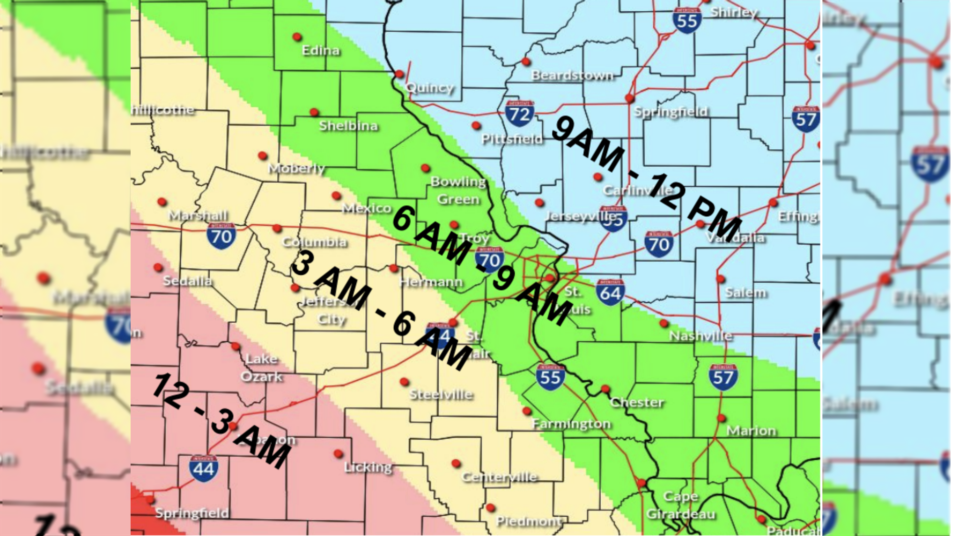
Fuchs said the weather event will begin Saturday morning, Jan. 24, 2026, and continue with periods of snow through Sunday morning, Jan. 25, 2026, tapering off by Sunday evening.
“The rapid accumulation of snow will make travel extremely difficult, if not impossible,” Fuchs said.
Fuchs also highlighted the extreme cold temperatures expected following the storm. He forecasted subzero lows Monday morning, Jan. 26, 2026, with wind chills potentially reaching minus 10 degrees in the Metro area and as low as 15 to 20 degrees below zero in northeast Missouri.
Monday, Jan. 26, 2026, and Saturday morning, Jan. 24, 2026, are expected to be the coldest, with temperatures remaining cold throughout the week.
The National Weather Service in St. Louis announced on Thursday a cold weather advisory in effect from midnight Friday night to noon Saturday for portions of south central and southwest Illinois, as well as central, east central, and southeast Missouri. Wind chills as low as 15 degrees below zero are anticipated, posing risks of hypothermia and frostbite. Officials advise residents to use caution while traveling outdoors and to wear appropriate clothing, including hats and gloves.
Simultaneously, a winter storm warning is in place from midnight Friday night, Jan. 23, 2026, until 6 p.m. Sunday, Jan. 25, 2026, covering the same general region.
The warning calls for heavy snowfall with total accumulations between 5 and 10 inches, and locally higher amounts are possible.
Travel conditions are expected to be very difficult to impossible during the storm.
The National Weather Service has expanded the winter storm watch to include additional counties in central Missouri, effective from midnight Saturday to 6 a.m. Sunday. Snowfall of 5 or more inches is possible in these areas, with lesser amounts farther north. Due to uncertainty in the timing and total snowfall, residents are urged to stay updated on the latest forecasts and prepare accordingly.
Officials emphasize the importance of taking precautions during this prolonged period of severe winter weather, especially for vulnerable populations such as the elderly. The combination of heavy snow and dangerously low wind chills presents significant hazards across the region.
- Cold Weather Advisory
COLD WEATHER ADVISORY REMAINS IN EFFECT FROM MIDNIGHT FRIDAY NIGHT TO NOON CST SATURDAY
- WHAT...Very cold wind chills as low as 15 below expected.
- WHERE...Portions of south central and southwest Illinois and central, east central, and southeast Missouri.
- WHEN...From midnight Friday Night to noon CST Saturday.
- IMPACTS...The dangerously cold wind chills as low as 15 below zero could result in hypothermia or frostbite if precautions are not taken.
- PRECAUTIONARY/PREPAREDNESS ACTIONS... Use caution while traveling outside. Wear appropriate clothing, a hat, and gloves.
Winter Storm Warning
National Weather Service St. Louis MO 115 PM CST Thu Jan 22 2026
WINTER STORM WARNING IN EFFECT FROM MIDNIGHT FRIDAY NIGHT TO 6 PM CST SUNDAY...
- WHAT...Heavy snow expected. Total snow accumulations between 5 and 10 inches with locally higher amounts possible.
- WHERE...Portions of south central and southwest Illinois and central, east central, and southeast Missouri.
- WHEN...From midnight Friday Night to 6 PM CST Sunday.
- IMPACTS...Travel could be very difficult to impossible.
- PRECAUTIONARY/PREPAREDNESS ACTIONS... The rapid accumulation of snow will make travel extremely difficult, if not impossible. If travel is necessary, be sure to exercise extreme caution.
More like this:


- Most Popular


- Top Stories


- Most Recent


- Sign In
- Home
- Video
- News
-
Weather
 Sponsored by Michael Ryan Exteriors - Roofing Professionals
 - Sports
- Obits
- Events
- Radio
- AP News
- Shop Local
- Classifieds
- Autos
- Real Estate
- Directory
Get the RiverBender App


Follow Us
Copyright © 2026 RiverBender.com All rights reserved.
primary