

Region Faces Rare Moderate Severe Weather Risk
Forecasters predict a band of thunderstorms moving southward today, bringing all forms of severe weather between 2 p.m. and 10 p.m. in the bi-state Metro area.

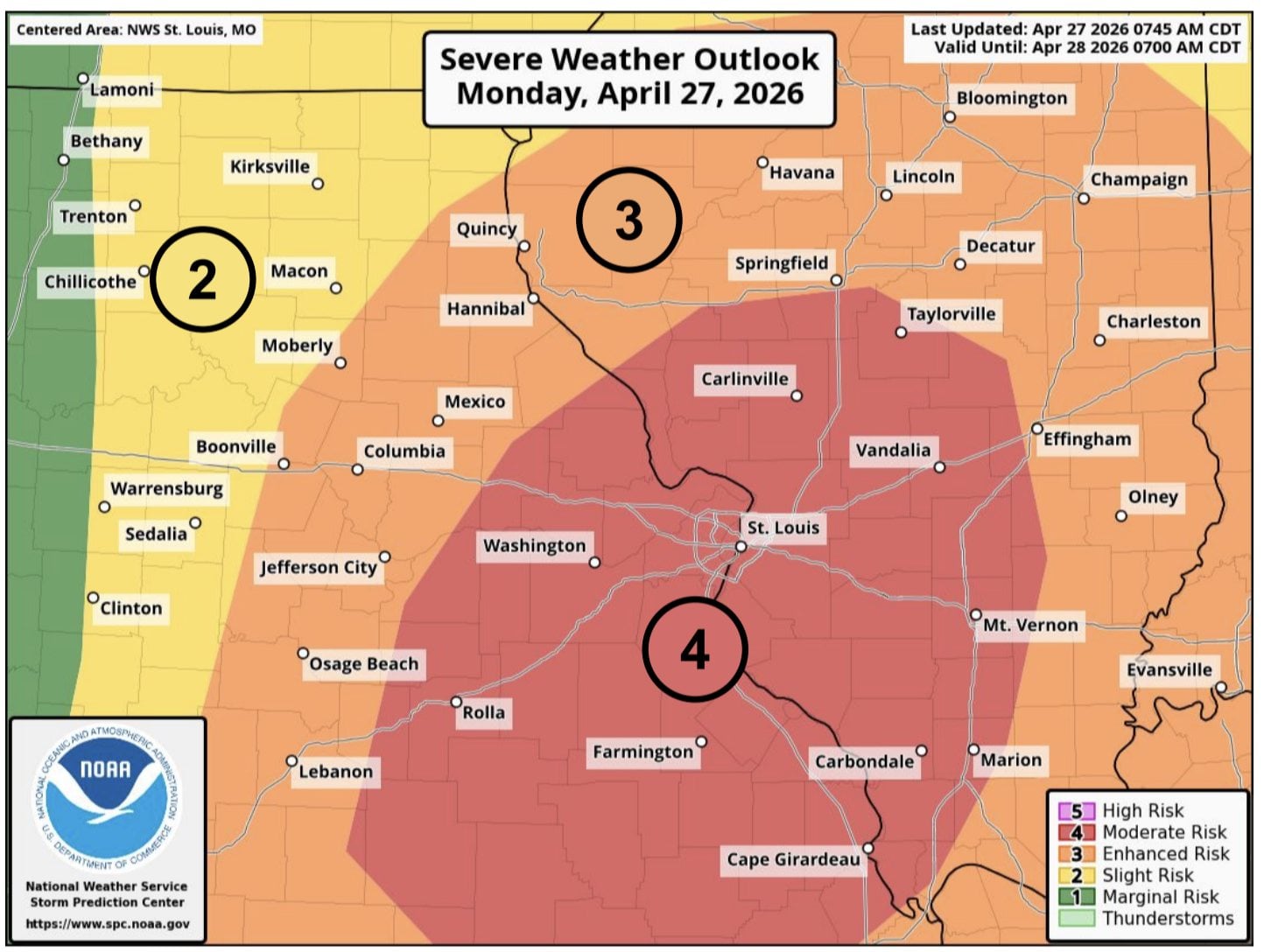
 ST. LOUIS - A rare, higher-end severe weather threat is expected to build across the St. Louis region this afternoon and into tonight, with forecasters warning that storms could bring tornadoes, damaging winds, and large hail.
The National Weather Service in St. Louis has upgraded the area to a Moderate Risk, or Level 4, for severe thunderstorms today, with the most likely window for severe weather between 2 and 10 p.m., meteorologist Mark Fuchs said on Monday morning, April 27, 2026. Forecasters said a band of thunderstorms is expected to sag into the bi-state and metro area, especially the north side by midafternoon, then move southward into the late evening.
Get The Latest News!
Don't miss our top stories and need-to-know news everyday in your inbox.
“We are under moderate risk of severe weather for the rest of today into tonight,” Fuchs said.
Fuchs said the moderate risk level is rare and is being driven by “a lot of instability in the atmosphere,” with low pressure developing to the northwest and a cold front expected to push through the bi-state area overnight.
“We are concerned with the thunderstorm band that it will sag into the bi-state and metro area, especially the north side in the mid-afternoon and sagging southward into late evening. With this line, all forms of severe weather are possible, tornadoes, damaging winds, and hail,” he said.
In the Metro East, the most likely time for severe storms is midafternoon, between 2 and 5 p.m., according to Fuchs.
Fuchs added that Monday afternoon “could feature multiple storms moving along that way.”
Thunderstorms this afternoon and evening could produce up to baseball-sized hail, damaging winds, and tornadoes, according to the forecast.
More like this:

- Most Popular


- Top Stories


- Most Recent


- Sign In
- Home
- Video
- News
-
Weather
 Sponsored by Michael Ryan Exteriors - Roofing Professionals
 - Sports
- Obits
- Events
- Radio
- AP News
- Shop Local
- Classifieds
- Autos
- Real Estate
- Directory
Follow Us
Copyright © 2026 RiverBender.com All rights reserved.
primary