

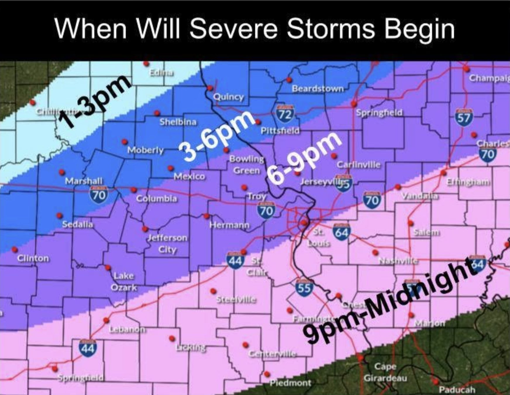
Severe Weather Threat Shifts To Evening Storms
A tornado watch had been issued for parts of the region on Wednesday morning, but forecasters say the bigger concern now is a second wave of storms expected later today.

 JERSEYVILLE/ALTON/EDWARDSVILLE - A tornado watch remained technically in effect Wednesday morning, June 17, 2026, for Montgomery, Macoupin, Jersey, Calhoun, Greene, Pike, Brown, and Adams counties in Illinois, but the threat had “severely lessened” after showers and storms moved through most of the area, Melissa Delia, a meteorologist for the National Weather Service in St. Louis, said.
Delia said the National Weather Service in St. Louis forecasters are predicting two rounds of showers and thunderstorms on Wednesday, June 17, 2026, with the greater concern now shifting to a second round expected late in the afternoon and into the evening across the entire forecast area, including Illinois counties.
Get The Latest News!
Don't miss our top stories and need-to-know news everyday in your inbox.
“I would say the best chance for severe weather tonight is between 5 and 10 p.m., and that covers all your coverage area,” Delia said.
She said the greatest risk is expected in the northern counties of the coverage area, where the most serious threat is forecast between 5 p.m. and 8 p.m. Delia said the threat is expected to diminish farther south and later into the evening.
“The current watch is for showers and storms that already moved through most of the area,” Delia said. “Technically still in effect, not cancelled, but the storm warnings issued are no longer posing a severe threat.”
Storms are expected to move in from the north and northwest, she said.
Delia said severe thunderstorm warnings can bring winds of 60 to 70 mph, with 70 mph possible in the strongest storms. She said the most intense conditions are most likely during the 5 p.m. to 8 p.m. period, before conditions weaken later in the evening.
- Most Popular


- Top Stories


- Most Recent


- Sign In
- Home
- Video
- News
-
Weather
 Sponsored by Michael Ryan Exteriors - Roofing Professionals
 - Sports
- Obits
- Events
- Radio
- AP News
- Shop Local
- Classifieds
- Autos
- Real Estate
- Directory
Get the RiverBender App


Follow Us
Copyright © 2026 RiverBender.com All rights reserved.
primary